


As Los Angeles firefighters battle the remaining hotspots more than a week into deadly blazes, scientists and engineers hope the growing availability of satellite data will help in the future.
Low-earth orbit is generally less than 1,000 km above the surface. Satellites here offer high-resolution ground images, but see any given point only briefly as they sweep around the planet.
Geostationary satellites orbit at around 36,000 km, remaining over the same area on the earth’s surface, allowing for continuous observation but usually at much lower resolution.
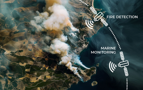
New satellite projects, like the 55-satellite constellation, aim to provide detailed, frequent fire data with 5-meter resolution.
German company OroraTech launched the first of at least 14 FOREST-3 nanosatellites on January 14 to provide fast wildfire alerts and high-quality thermal data.
Challenge : The large volume of satellite data, such as 1TB daily from ESA’s Sentinel-2, requires machine learning to process and predict fire outbreaks more effectively.


COMMENTS